As always, I would like to reiterate that I believe the Sweeney’s to be very forthright, respectable people. I appreciate their making so much information available to us for a thorough review of their proposed project. My comments refer to the Treasure Hill proposed development and not to the Sweeney’s personally.
CUP Criteria 8: Building mass, bulk, and orientation, and the locations on the site; including orientation to buildings on adjoining lots.
December 18, 1985 planning commission approval addresses SCALE: A couple exerpts
“Located in the historic district, it is important for the project designed to be compatible with the scale already established.”
“The focus or thrust of the review process has been to examine different ways of accommodating the development of the property while being mindful of and sensitive to the surrounding neighborhood.”
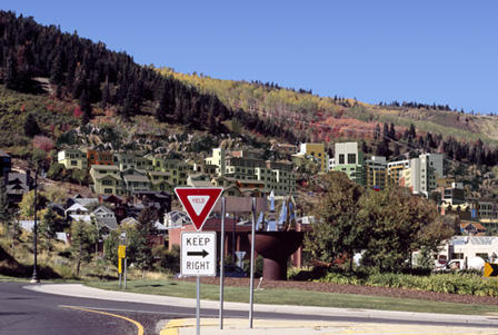
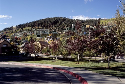
While buildings 1A and 2 are possibly the most compatible in the project. Their location and orientation present a road on top of an approximately 22 foot vertical wall. The wall will be very pronounced in old town and it will not be a welcome design feature, nor is the exposed road.
Bldg 1B is 6 stories and quite massive for its location at the midstation site above Woodside Ave and could be broken up similar to 1A.
Massing issues exist with most bldgs, but especially:
Bldg 5A: 11 stories 150’ tall & 60,000 sq ft w/ 39% circulation, common space, & accessory
Bldg 5C: 12 stories 145’ tall & 81,000 sq ft w/ 37% circulation, etc…
Bldg 4B: 13 stories 137’ tall & 252,000 sq ft w/37% circulation, etc…
The over riding design features on the site are bldg positioning and orientation to allow for maximum heights through excavation of the existing hillsides. This excavation is proposed at unprecedented volumes. This will be addressed with CUP criteria 15.
CUP Criteria 11: Physical design and compatibility with surrounding structures in mass, scale, style, design, and architectural detailing;
As discussed in the staff report and public input, mass and scale are not compatible with surrounding structures.
Style, design, and architectural detailing should be determined by the historic district design guidelines. This is required by the original planning commission approval dated December 18, 1985:
“MPE Inc., its successors or assignees, shall be bound by and obligated for the performance of the following:”
III. Item 6: “At the time of project review and approval, all buildings shall be reviewed for conformance with the Historic District Design Guidelines and related architectural requirements.”
These Treasure Hill buildings have not passed review with the Historic District Design Guidelines.
CUP Criteria 15: Within and adjoining the site impacts on environmentally sensitive lands, slope retention, and appropriateness of the proposed structure to the topography of the site;
The topography of the site should be respected by the proposed development. It is not.
Every tree, bush and blade of grass will be removed from the proposed site. This will destabilize all the soil in the project above Old Town. Mudslides and snow slides were known to happen at this site in the past. There was a 1926 law titled “PROTECTION OF STANDING TIMBER ON TREASURE HILL. DANGEROUS EXCAVATION”. Tree cutting on Treasure Hill was punishable by $100 fine or up to 90 days in jail. There was also a deadly slide in Daly in 1948 and another large slide on the other side of Empire canyon in the late 1960’s.
The developers site plan from Alta Engineering calls for an estimated 960,000 cubic yards of excavation. To give some scale to this, think of an average dump truck. It carries 12 cubic yards of dirt. That is 80,000 single dump truck loads.
Another example for scale. The Montage development in Empire Pass had approximately 780,000 sq ft and their estimated excavation from the site was 50,000 CY.
Treasure Hill plans to move almost 20 times as much dirt as the Montage planned to move.
The developers are adamant that no dirt will be removed from the site, it will be relocated on the mountain. How can this be guaranteed when there are 4 mining sites within close proximity to the proposed development. 3 of these sites have elevated levels of lead and arsenic. The Creole Adit is within the proposed development and contains 11,000 PPM Lead which is 11 times the acceptable limit as required by the city.
These 4 mining sites have not been mapped in detail and full geologic and geotechnical data are not available as yet from the developers. From the Alta Engineering document, it appears Treasure Hill Bldg 4A sits directly on top of the Creole Adit. This horizontal shaft appears to run NW to the Creole Mine Shaft and beyond. If this is the case, the largest hotel bldg 4b also sits directly on top of the Creole Adit. Again, more data is needed to confirm this and understand the depth and extent of the mining activity.
Again as an example, The Montage had extensive geotechnical work done prior to development. Only 4 mining operations were found to exist at the Montage site. After excavation commenced, an additional 4 mining operations were found at the site. This required the Montage developers to remove another unexpected 40,000 CY of dirt. Nearly double the total excavation and removal of contaminated soils from mining activity to Richardson Flats.
There is no approved soil remediation plan in place as yet from the Treasure Hill developers. Their plan was to take the contaminated Creole Adit soils up to the Creole mine shaft and dump them down into the shaft (which is also contaminated), then cap the shaft with semi permeable soils. The city has rejected this plan.
PCMC’s letter dated August 28, 2006 states, “PCMC does not agree with the strategy of transporting a higher concentration mine waste (Creole Adit 11,000PPM lead) to a lower concentration site (Creole Mine Shaft 2,200 PPM lead) for permanent placement within a shaft. In addition, the City would consider such placement within the Creole Mine Shaft as a potential “pollution source” for the Spiro Drinking Water protection Zone, which is prohibited per PCMC’s Drinking Water Source Protection Plan ordinance detailed in Section 13-1-28.” Of the code.
The Creole Mine Shaft is within the Spiro Drinking Water Source Protection Zone.
This is where much of the city’s drinking water comes from. It must be protected.
The developers are planning unprecedented excavation and there is no guarantee that this is even near the final reality of how much soil will be moved or removed from the site.